Google’s Quiet Censorship of Gaza’s Satellite Imagery
Google have begun showing users older images of Gaza, hiding the devestation of Israel's campaign of Genocide began.
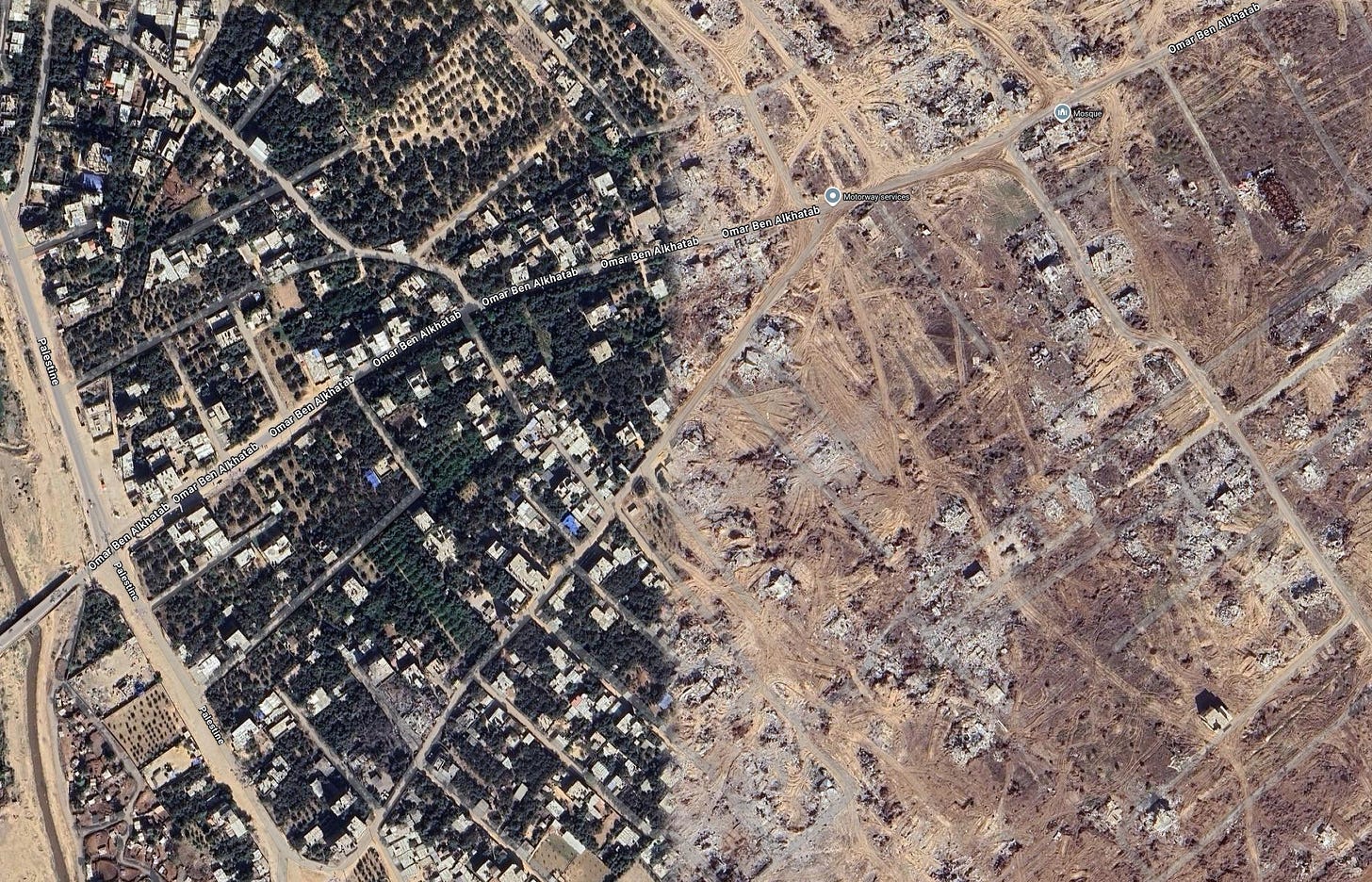
Open Google Maps. Zoom in on Gaza. The streets look mostly intact, buildings stand in place, and the dense neighborhoods of Rafah, Khan Younis, and Gaza City are frozen in time. There is no sign of the pulverized city blocks, very little scarred earth, not much hint of the mass displacement that has reshaped the territory.
But this Gaza is a lie.
The real Gaza, the Gaza of 2025, is flattened. Whole districts are reduced to rubble. Roads are cut by bomb craters. Thousands of homes are gone, replaced by grey dust and tangled steel. You can see it if you know where to look, buried inside Google Earth’s Historical Imagery feature, or in tiles that appear only after deliberate searching. But by default, Google is showing the world a pre-destruction Gaza from 2023.
This is not a glitch. The updated images exist. They have been available in Google Earth since December 2024. Media outlets and NGOs like Médecins Sans Frontières have used them in public comparisons, contrasting August 2023 neighborhoods with their December 2024 obliteration. But unless you toggle the right settings, you will never see them.
The difference is staggering. In Jabalia, densely packed residential zones are now skeletal remains. In central Gaza City, schools and hospitals are cratered shells. In Khan Younis, entire rows of apartment blocks have been vaporized. The UNOSAT damage assessment of December 13, 2024 confirms the scale, showing thousands of destroyed structures mapped from satellite data.
The effect of hiding them in a buried “historical” layer is obvious. The destruction disappears from casual view. Journalists relying on default Google Maps screenshots see intact streets. Educators, researchers, and the public are given a Gaza that predates Israel’s most intense military operations.
Google Earth is built from a patchwork of satellite and aerial tiles, each with a capture date. In most cases, the platform’s algorithm surfaces what it considers the “best” image for clarity and coverage. But that choice is subjective. A bright, cloud-free image from 2023 might be preferred over a newer but dustier or lower-resolution 2024 shot, even if the newer one documents massive war damage.
That decision is not neutral. The “best” image in Google’s eyes may also be the most politically convenient. When the destruction of Gaza is pushed into a secondary menu labeled “Historical Imagery,” it is framed as the past, not the ongoing reality. And because most users never touch that tool, the practical result is erasure.
Google’s map choices cannot be viewed separately from its business interests. Under Project Nimbus, a joint deal with Amazon worth around 1.2 billion dollars, Google provides AI, cloud, and surveillance infrastructure to the Israeli government, including its Ministry of Defense.
Signed in 2021, Nimbus has been the subject of internal revolts: employee walkouts, open letters, and firings of staff who spoke out. In 2025, Alphabet shareholders pushed resolutions demanding human rights due diligence for contracts in Conflict-Affected and High-Risk Areas (CAHRAs), but the board urged investors to vote them down.
The overlap is uncomfortable. Google profits directly from the state responsible for Gaza’s destruction, while controlling one of the primary public visual records of that destruction. Choosing an older, cleaner image over a newer, obliterated one is not just an aesthetic decision, it is a choice that benefits a paying client.
What is happening in Gaza feels different. The newer images are already public inside Google Earth, just hidden from default view. That is not about security, it is about perception.
In a genocide, visibility is everything. The ability to see the aftermath of bombings, the erasure of neighborhoods, and the mass destruction of civilian infrastructure are not just visuals, they are evidence. They can be used in war crimes investigations, humanitarian appeals, and historical records.
By controlling what the average person sees when they type “Gaza” into Google Maps, the company is not just curating, it is shaping the narrative. A sanitized Gaza is less likely to provoke outrage, less likely to mobilize pressure on Israel, and less likely to damage Google’s own lucrative military relationships.
The rubble is there. Google just does not want you to see it.